The origin of Grand Canyon
The origin of Grand Canyon
(by late-Flood channelized flow)
by Michael Oard
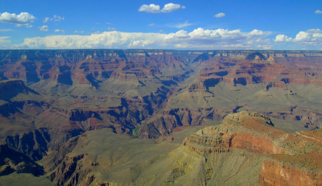 Grand Canyon (fig. 1) is one of the most visible and studied icons of geology. It is the valley of the Colorado River and is 466 km (290 mi) in river length, if the 97 km of Marble Canyon are included. Its depth varies from about 900 m (3,000 ft) to 1,800 m (average depth is 1,610 m). The canyon’s width rim-to-rim is between 6.4 and 29 km (4–18 mi). The total amount of rock eroded from the canyon was 3,300–4,100 km3 (800–980 mi3).
Images: Mike Oard (unless otherwise stated) Fig. 1. Grand Canyon, northern Arizona (view north from Yavapai Observation Station, South Rim). The side Canyon is Bright Angel Canyon, caused by the Bright Angel Fault down which the North Kaibab trail runs.
A showcase for anticreationists
Anticreationists consider Grand Canyon a showcase for uniformitarian geology and proof against biblical creation and the Flood.1 They regard it as being on the ‘front lines’ of the origins battle:
The famous landscape of the Grand Canyon lies along the front lines of competing scientific and nonscientific [i.e., creationist] views of Earth’s antiquity and evolution.2
Secularists regard creationist views as ‘nonscientific’ because we do not accept that present ‘slow and gradual’ (uniformitarian) processes explain the rocks and fossils. The point of contention is Noah’s Flood.
Slow-and-gradual can’t explain Grand Canyon
Uniformitarian scientists assume that the Colorado River, or some precursor river, cut the canyon. But the canyon’s path does not follow secular geological logic. It cuts through high plateaus, is not diverted by faults, and does not follow the topographic slopes of the bounding plateaus. Thus, Grand Canyon defies the principle of uniformitarianism upon which all secular geological interpretations are based.3
Two creationist hypotheses
Creationist researchers have developed two basic hypotheses on the origin of Grand Canyon: (1) post-Flood dam breach and (2) late-Flood channelized erosion.
Flood geology has become increasingly sophisticated since its modern revival in the 1960s. Creationist researchers have developed two basic hypotheses on the origin of Grand Canyon: (1) post-Flood dam breach and (2) late-Flood channelized erosion.
The dam-breach hypothesis proposes two large lakes, which they call Canyonland and Hopi Lakes, left over from the Flood. These continued to rise from heavy post-Flood precipitation during the Ice Age.4 After many years, it was thought, these lakes suddenly breached and cut through the high plateaus, forming Grand Canyon.
The second hypothesis states that late Flood erosion, after the receding floodwater transformed from sheet flow to channelized flow, carved Grand Canyon from the top down.5,6,7,8,9,10 It has become the more widely accepted concept among creation geologists.
Evidence against dam breach
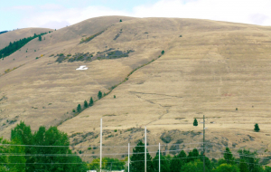 Fig. 2. Shorelines from glacial Lake Missoula on Mount Jumbo, northeast of Missoula, Montana.
At one time I favoured the dam-breach hypothesis. But I abandoned it on discovering that the field evidence does not support it.11 I found four major difficulties.12,13
First, there is a lack of any shorelines from the postulated lakes. Ice Age lakes, however, commonly have them—e.g. glacial Lake Missoula, Montana (fig. 2).
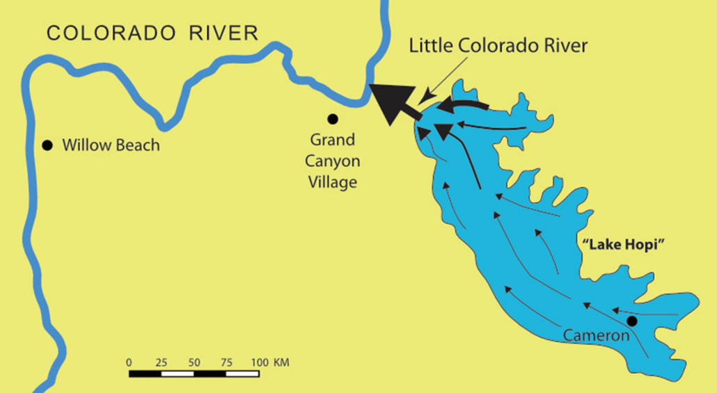
Second, lakes almost always have sediments in their deepest parts. There are no such bottom sediments where these lakes are supposed to have been. Could they have been washed out during the dam breach? The valley that supposedly contained ‘Lake Hopi’ is wide, but the canyon, which is believed to have formed during the postulated dam breach, is a narrow slot canyon (fig. 3). The currents flowing through this canyon would have been strong, but bottom currents in Lake Hopi would still have been too weak to erode the bottom sediments (fig. 4). When glacial Lake Missoula in western Montana burst at the peak of the Ice Age, the water rushed out of the lake at over 90 km/h but left a large amount of bottom sediment.
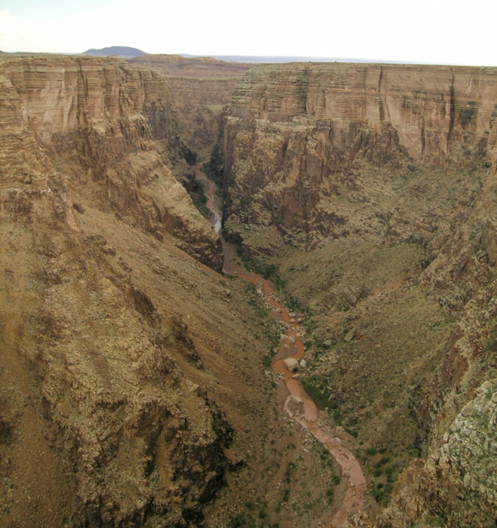 Fig. 3. The narrow valley of the Little Colorado River Valley at a scenic overlook at milepost 285.7 on highway 64. The canyon at this point is a slot-like canyon about 370 m (1,200 feet) deep.
Third, a dam breach would not carve the long side canyons. Grand Canyon has two 1.6 km-deep, 50-km long, narrow side canyons that end at the Colorado River, one from the north and the other from the south (fig. 5). Water from the dam breach would be narrowly focused down the main canyon from the east, and not down the side canyons, from the north and south. To have water flowing down the side canyons, the water flow from the breach would have to have been over 100 km wide.
Finally, if Grand Canyon formed from a dam breach, there should be a large delta at the mouth of the canyon where the currents slowed. They should have dropped a massive amount of sediment, including large boulders. The Lake Missoula flood, rushing at up to 120 km/h through the Columbia Gorge between Oregon and Washington states, USA, slowed in the wide valley in the Portland/Vancouver area and formed a huge delta. It is about 500 km2 in area, up to 100 m deep, and with numerous boulders scattered across it. There is no such delta out from the mouth of Grand Canyon.
Flood erosion works
Drawn by Peter Klevberg Fig. 4. Schematic of postulated currents in “Lake Hopi” and the Little Colorado River Canyon.
 Late Flood channelized erosion can explain many mysteries in Grand Canyon’s origin.5,14 In the first 100 days or so after the Flood’s peak, massive sheet-like flow off the land into the relatively deepening ocean basins would have eroded vast areas, planing them flat. Secular geologists accept that, before Grand Canyon was carved, about 3,000 m thickness of sediments and sedimentary rocks were eroded from 130,000 km2 in the Grand Canyon area. They call this the ‘Great Denudation’.10
As the water level dropped, this sheet flow would start to divide into individual channels across the underlying surface, intensifying the erosion beneath each channel, cutting it rapidly and deepening grooves in the land surface. This receding water quickly carved Grand Canyon and other canyons, like Zion Canyon. The eroded sedimentary load was emptied into deep basins in southeast California and the ocean.11,15
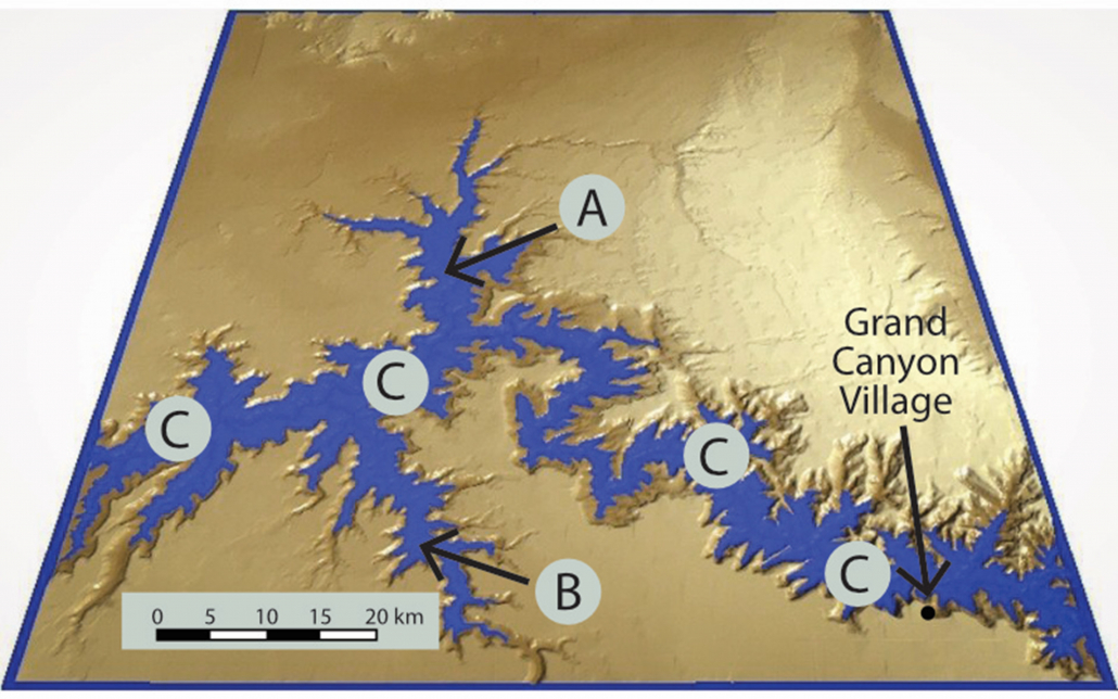 Adapted from Scheele, ref. 5, fig. 16. Fig. 5. The main 95 km (60 mile) portion of Grand Canyon, Arizona, with digital simulation of raised water level as Noah’s floodwaters receded. The Colorado River (C) flows from right to left (east to west). Two prominent side canyons are arrowed, Kanab Canyon (A) to the north and Havasu Canyon (B) to the south.
A canyon which passes perpendicularly from one side of a mountain range or ridge to the other, and which contains a river, is called a water gap. There are thousands of such water gaps on the earth.16 Grand Canyon is the world’s longest water gap, though not its deepest. Water gaps overall pose a puzzle for uniformitarian geologists, who generally assume that the river carved the gap. But rivers should logically flow around mountain ranges, not cut through them. Channelized Flood erosion as water level dropped solves the mystery. The gap is eroded first and the river later takes advantage of the passage formed.
Grand Canyon, too, avoids the ‘logical’ path. It passes straight through several high plateaus, instead of going around them. And it does not cut through the first, the Kaibab Plateau, at its lowest point. Secular Grand Canyon expert, Wayne Ranney, is perplexed:
Oddly enough, the Grand Canyon is located in a place where it seemingly shouldn’t be. Some twenty miles east of Grand Canyon Village the Colorado River turns sharply ninety degrees, from a southern course to a western one and into the heart of the uplifted Kaibab Plateau … . It appears to cut right through this uplifted wall of rock, which lies three thousand feet above the adjacent Marble Platform to the east.17
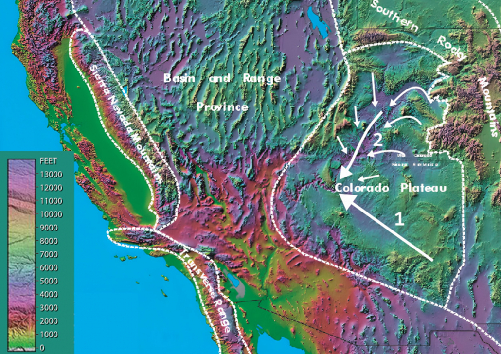 Base image courtesy of Ray Sterner and Peter Klevberg. Fig. 6. Two broad currents becoming one. Number 1 down the present Little Colorado River Valley and number 2 coming from the main valley of Canyonlands National Park. Note that the waters of Noah’s Flood covered the whole area at this time.
The hardest problem (for both secular and creationist researchers) is explaining how the Kaibab Plateau was cut through at a present-day altitude of about 2,500 m and not at its lowest point of 1,740 m, where it would have been the easiest. This can be explained by two channelized currents approaching from the northeast and southeast each cutting their own valley until they joined forces on the Kaibab Plateau at the location of the eastern Grand Canyon (fig. 6). The combined current would then accelerate, becoming very erosive, and would cut a water gap at the intermediate altitudes of the Kaibab Plateau from the top down.
Conclusion
The global Flood is a fact of history. Late Flood channelized flow as the waters receded is a straightforward concept derived from taking Scripture at face value. So, it is not surprising that it provides reasonable answers to several features of Grand Canyon that remain a mystery within the secular uniformitarian framework.17
References and notes
- Strahler, A.N., Science and Earth History—The Evolution/Creation Controversy, Prometheus Books, Buffalo, NY, 1987. Return to text.
- Pederson, J., Young, R., Lucchitta, I., Beard, L.S., and Billingsley, G, Comment on ‘Age and evolution of the Grand Canyon revealed by U-Pb dating of water table-type speleothems,’ Science321:1634b, 2008. Return to text.
- Oard, M.J., The origin of Grand Canyon part I: uniformitarianism fails to explain Grand Canyon, CRSQ46(3):185–200, 2010. Return to text.
- Austin, S.A., Holroyd III, E.M., and McQueen, D.R., Remembering spillover erosion of Grand Canyon, ARJ 13:153–188, 2020. Return to text.
- Scheele, P., A receding Flood scenario for the origin of the Grand Canyon, Creation24(3):106–116, 2010; creation.com/gc-origin. Return to text.
- Oard, M.J., The origin of Grand Canyon Part III: a geomorphological problem, CRSQ47(1):45–57, 2010. Return to text.
- Oard, M.J., The origin of Grand Canyon Part IV: the great denudation, CRSQ47(1):146–157, 2010. Return to text.
- Oard, M.J., The origin of Grand Canyon Part V: carved by late Flood channelized erosion, CRSQ47(4):271–282, 2011. Return to text.
- Clarey, T., Lava flows disqualify lake spillover Canyon theory, Acts & Facts 49(10):10–12, 2020. Return to text.
- Clarey, T., Carved in Stone: Geological Evidence of the Worldwide Flood, Institute for Creation Research, Dallas, TX, 2020. Return to text.
- Oard, M.J., Comments on the breached dam theory for the formation of the Grand Canyon, CRSQ30:39–46, 1993. Return to text.
- Oard, M.J., A dam-breach unlikely for the origin of Grand Canyon. CRSQ57:206–222, 2021. Return to text.
- Oard, M.J., The Origin of Grand Canyon Part II: Fatal problems with the dam-breach hypothesis, CRSQ46(4):290–307, 2010. Return to text.
- Oard, M.J., A Grand Origin for Grand Canyon, Creation Research Society, Glendale, AZ, 2016 (available as ebook creation.com/s/35-5-062). Return to text.
- For details, see ref. 14. Return to text.
- Oard, M.J., Water and wind gaps carved during channelized Flood runoff, Creation41(2):38–41, 2019; creation.com/water-wind-gaps. Return to text.
- Ranney, W., Carving Grand Canyon: Evidence, Theories, and Mystery, Grand Canyon Association, Grand Canyon, AZ, p. 20, 2005. Return to text.
![]() Posted on homepage: 29 May 2023 at https://creation.com/
Posted on homepage: 29 May 2023 at https://creation.com/
Learn more about how Science Proves Creation
![]()
